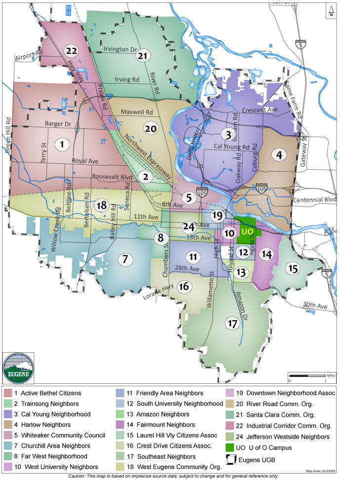
We have compiled a list of real estate areas located in Eugene, Oregon.

Neighborhoods
This is meant to be a jumping off point for your Lane County real estate research. Please contact us if you have further questions concerning the various locales around Eugene. We have spent years living and working here and have a lot to offer when it comes to choosing the right location. Everyone has specific needs and budgets. Let us connect with you and help you find a home that’s the perfect fit. More neighborhood info below.

Bethel-Danebo
Bethel-Danebo has seen amazing growth in the past 10 years. The community has its own school district, and is near shopping and the airport. Bethel-Danebo is located in west Eugene and is bounded by Hwy 99 on the east; Greenhill Rd on the west; Clear Lake Rd on the north; and Southern Pacific Coos Bay Line on the south.

For more information about Bethel-Danebo click here

Properties available in Bethel-Danebo


Neighborhoods - Bethel-Danebo Boundary Map

College Hill
College Hill is comprised of everything between Willamette Street and Friendly Street between 18th and 29th. The neighborhood consists of mainly single family homes in a quiet setting. Many of the homes have beautiful views overlooking Eugene. The college of “College Hill” refers to the former location of Columbia University, which was located on the northeast portion of College Hill.

For more information about College Hill click here

Properties available in College Hill


Neighborhoods - College Hill Boundary Map

Downtown Eugene
Downtown is basically anything within a 15 minute walk of Broadway Plaza. Downtown boasts many local eateries, art galleries, shops, the city library, theaters, clubs and businesses.

For more information about Downtown click here

Properties available Downtown


Neighborhoods - Downtown Boundary Map

Fairmount
The Fairmount Neighborhood owes its name and many of its unique characteristics to a short-lived 19th-century development known as Fairmount City. Annexed into the city of Eugene in 1902, this development’s legacy is preserved in generously-sized residential lots, the curvilinear design of Fairmount Boulevard, and a large neighborhood park- part of which was later incorporated into Hendricks Park. The Fairmount Neighborhood has since ascended into the forested hills to the south and east, and is now contiguous with adjacent Eugene neighborhoods. Many residents enjoy the easy walking distance to several commercial districts featuring conveniences such as restaurants, groceries, bakeries, pet care, auto repair, and more. Fairmount is also just east of the University of Oregon Campus.

For more information about Fairmount click here

Properties available in Fairmount


Neighborhoods - Fairmount Boundary Map

Ferry Street Bridge
Ferry Street Bridge is located just north of the river from Downtown Eugene. Located in this area are the Willamette River, restaurants, parks, shopping centers, spas, 2 golf courses and easy access to 1-5. Bike paths and bridges make biking super fun and easy! The Ferry Street Bridge Neighborhood is in the area bounded by Interstate 5 on the east; the Willamette River on the south and west and Randy Pape Beltline on the north.

For more information about Ferry Street Bridge click here

Properties available for Ferry Street Bridge


 Neighborhoods- Ferry Street Bridge Boundary Map

Friendly Area
The Friendly Area Neighborhood is named for Friendly Street, that bisects the neighborhood from North to South. The street was named for Sam Friendly, a much-loved 19th century mayor of Eugene, and one of the far-sighted individuals who secured the location of the University of Oregon for Eugene. His direct descendant was Fred Friendly, the internationally renowned broadcast journalist. This neighborhood encompasses a wide range of architectural and personal styles. Residents of the Friendly Area Neighborhood love to garden and this common thread of love and pride is visible on every street. The street trees that flourish were planted, in part, through the efforts of the Friendly Area Neighbors Association (FAN).

For more information about Friendly Area click here

Properties available in Friendly Area


Neighborhoods - Friendly Boundary Map

Gilham
The Gilham neighborhood contains many amenities including major shopping centers, several grocery stores, parks, fire station, police station and a golf course. The vast majority of land supports low density residential uses. Major commercial uses are located along Coburg Road.

For more information about Gilham click here

Properties available in Gilham


Neighborhoods - Gilham Boundary Map

Laurel Hill Valley
The physical boundaries of the Laurel Hill Valley Neighborhood are defined as the watershed bounded by a ridge line around the valley that starts at Hendricks Park at the west; to 30th Avenue to the south and continuing along knolls of 870 feet and 897 feet elevations at the southeast; and northward to a knoll of 898 feet elevation and continuing northwest and north along Laurel Hill Drive to the Glenwood exchange and Interstate 5. The key word is watershed, and includes the knoll known locally as Moon Mountain. It is an area with a unique rural character within the city limits and the UGB. The area enjoys easy access to I-5 and the University of Oregon campus.

For more information about Laurel Hill Valley click here

Properties available in Laurel Hill Valley


Neighborhoods - Laurel Hill Valley Boundary Map

River Road
River Road Neighborhood sits northwest of downtown and with its river bike paths it’s easy to get around town from here. Mostly residential, with some support businesses, this older community boasts large lots and a mix of old and new construction. River Road is bounded by Southern Pacific Coos Bay Line on the south; NW Expressway on the west; the Willamette River on the East and Randy Pape Beltline on the north.

For more information about River Road click here

Properties available in River Road


Neighborhoods - River Road Boundary Map

Santa Clara
The far north community of Santa Clara is the last you’ll see of Eugene before entering the farmlands of Lane County. Santa Clara has shopping, schools and many lovely parks. Santa Clara’s boundaries are Randy Pape Beltline at the south; NW Expressway to the west; Sovern Lane to the north and the Willamette River to the east.

For more information about Santa Clara click here

Properties available in Santa Clara


Neighborhoods - Santa Clara Boundary Map

South Hills
The South Hills region of Eugene lies between SE Eugene and SW Eugene. This diverse area includes upscale homes as well as low income housing, schools, hiking (Ridgeline Trail), and places to shop and socialize. Many homes have fabulous city or mountain views.

For more information about South Hills click here

Properties available in South Hills


Neighborhoods - South Hills Boundary Map

Southeast Eugene
Southeast Neighborhood also includes a large part of the South Hills region. Historically active and politically involved, the Southeast area is a vibrant neighborhood of 12,419 people with 6,209 housing units of which 68% are owner occupied homes. With deer and wild turkeys walking by you’ll feel like you’re in the country. Hiking and biking are also very popular here.

For more information about Southeast Eugene click here

Properties available in Southeast Eugene


Neighborhoods - Southeast Eugene Boundary Map

Southwest Eugene
Many folks choose to live in this area for all it offers. With 5,376 housing units, 12,357 residents make their home here and 59% are owner occupied. Abundant hiking trails, schools, parks, shops and restaurants serve the neighborhood well.

For more information about Southwest Eugene click here

Properties available in Southwest Eugene


Neighborhoods - Southwest Eugene Boundary Map

University
University Area is bounded by 30th Avenue on the south; Franklin on the north; Hendricks Hill on the east and Willamette on the west. This is the area that immediately surrounds the University of Oregon campus. The area includes many single family homes as well as rentals of apartments, condos and residence halls. There are many businesses that surround campus and also support life in this neighborhood. Bike or walk to most everywhere you’d want to go from here.

For more information about University click here

Properties available in University


University Boundary Map

Whiteaker
Laid back, entertaining and fun. People who live and work in, what they call “The Whiteaker” or “The Whit”, describe it as a colorful, bohemian, artsy, interesting place to be: The alternative part of town. In the span of a few blocks there is a rainbow mural on the Glass Menagerie (glass pipe store), saltwater-taffy-colored bungalows in the East Blair Housing Cooperative, Red Barn Natural Grocery, and the blue and gold domes of St. John, the Wonderworker Serbian Orthodox Church. Local breweries of Ninkasi, Hop Valley and Oakshire call this neighborhood “home”. Eugene’s oldest neighborhood is spread out around an area north and south of the railroad tracks a few blocks from the Willamette River. The neighborhood has a distinctive core business area that stretches along Blair Boulevard and surrounding streets, roughly between 3rd and 7th Avenue.

For more information about Whiteaker click here

Properties available in Whiteaker


Neighborhoods - Whiteaker Boundary Map

Click here to view the 4J School Boundary Map